Places is available on the Enterprise plan.
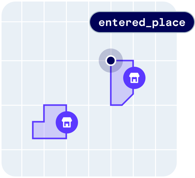
user.entered_placeuser.exited_place
Quickstart
First, sign up for Radar and get an API key. Then, enable Places events and enable chains or categories on the Settings page. From there, integrate the SDK and callRadar.trackOnce() or Radar.startTracking(), depending on your use case. Radar will generate an entry event on the first stopped location update at a place matching your enabled chains or categories.
How it works
Radar generates a place entry event if a user stops at a place (i.e., whenstopped is true based on tracking options or when foreground is true) matching filters with sufficient confidence, then a place exit event when the user leaves the place with sufficient confidence.
All place events have confidence levels, and places may have one or more categories and a chain.
Confidence
All place events have confidence levels. Confidence levels range from1 (low) to 3 (high). Confidence is a function of the accuracy of the location reported by the device, the footprint of the place, the density of the area, the popularity of the place, and other signals.
You may decide to ignore events based on confidence levels.
Categories
Places may have one or more categories. Radar supports hundreds of categories, organized in a hierarchy. View the full list of categories. You can listen for place events with specific categories. For example, to do something if a user is at an airport, on iOS:Chains
Places may have a chain. Radar supports thousands of U.S. and international chains. View the full list of chains. You can listen for place events with specific chains. For example, to do something when a user stops at a Starbucks, on Android:Mappings
To map Radar chain slugs to custom IDs, set Chain mappings under Places on the Settings page. You can set a JSON string representing a dictionary with keys and values of type string. For example, to mapburger-king to 123 and mcdonalds to 456:
place.chain.externalId in user context and events. These custom IDs can also be used in place of chain slugs when performing searches with the search places API.
Metadata
To map Radar chain slugs to custom metadata, set Chain metadata under Places on the Settings page. You can set a JSON string with values of type dictionary, each with between 1 and 16 keys and values of type string, boolean, or number. For example, to mapmetadata.category and metadata.offers for burger-king and mcdonalds:
place.chain.metadata in user context and events.
Place filters
We recommend filtering events to specific categories or chains under Places on the Settings page. For example, to monitor only fast food restaurants, you might addfast-food-restaurant to category filters, or add burger-king, mcdonalds, and others to chain filters.
View the full list of categories and the full list of chains.
State blocklist
To suppress tracking specific place categories in certain states, set Category state blocklist mapping under Places on the Settings page. For example, blocking thefast-food-restaurant category in New York would bypass visits to fast-food-restaurant places in New York.
Regions must be enabled to expose this setting.
Verify events
You can accept or reject places events after user check-ins or other forms of verification. Event verifications will be used to improve the accuracy and confidence level of future events. For example, to accept an event on iOS:Place matching
Place matching is available on the Enterprise plan.
How it works
- Import your geofences against Radar’s places data. Select chains to match your geofences against while importing your geofences into Radar.
- View the results of place matching. After the import has completed, look at the results on the Import history page. Click View import to see a summary and logs that indicate the outcome for each row. If the place match was successful, the import log will contain a link to the Radar place and the distance that the geofence center was corrected.
- Filter and export the results for further analysis. Apply Filters to isolate rows that were not place matched, geofences that have large center correction values, or errors. Click Export rows to download a CSV of the results.
Geofence types
circle: When acirclegeofence is matched, it will take on the geometry of the Radar place.polygon: When apolygongeofence is matched, it will be linked to the Radar place, but not adopt the place center or geometry.isochrone: When anisochronegeofence is matched, it will only take on the center of the Radar place, regenerating the isochrone geometry from the new center.
Advanced options
- Search radius. Place matching will look for the nearest location within 10 kilometers by default. This value can be reduced to enforce a tighter search distance.
- Geofence tag(s). Filter the rows to place match. For example, only perform place matching on rows where
tag = storebut nottag = nearby. - Use Radar’s place geometry. By default,
circlegeofences will adopt both the center and geometry of the Radar place. Toggle this off forcirclegeofences to take on the center but not the geometry.